

     | |
|
| |||
by Debbie Hum
Recently declassified American spy satellite images from the Cold War era are being used by a Concordia researcher to document tremendous environmental degradation on the Tibetan Plateau.
Since last July, Catherine Moore, a part-time lecturer in the Geography Department, has been working with sets of spy satellite images taken by the United States Geological Survey (USGS) in 1962, as well as non-military images from 1972 and 1989 to track the massive deforestation, heightened urbanization and consequent flooding on the southeastern Tibetan Plateau. Her research is being carried out in collaboration with the Environment Department of the Tibetan government-in-exile. Interviewed last week, Moore said the region's highly fragile ecosystem has been devastated by inappropriate "development."
Forests occupy only the southeastern portion of the Tibetan Plateau where the north-south trajectory of the region's mountains allow moist monsoon air to penetrate. It is a critical area environmentally, particularly in terms of the hydrology of Asia. The headwaters of at least seven of the major rivers in Asia are in the plateau, including the Yangtze, Mekong, Brahmaputra and others; almost 50 per cent of the human population are directly affected by these rivers.
"Deforestation has been devastating in a number of ways," Moore explained. "These river valleys have precipitously steep slopes. Where the forest has been removed, there's nothing to hold back the rain. The intensity of the summer monsoons falling on the denuded mountain slopes kicks up the soil and brings it down the slopes, where it enters the streams. With all the soil and sediments flowing into the river and settling down on the river bed and in the river channel, there is less room for water, and that's certainly contributing to the floods."
In fact, she said, after the flooding in 1998 along the Yangtze in China, in southeastern Asia and Bangladesh, which in many cases were the highest on record, the People's Republic of China called for a cessation to clear-cutting in the region, recognizing that it was a major factor in the flooding. "Our understanding is that there has been a very slow response there to the government edict, but at least they publicly recognize that that was a factor," Moore said.
The change of land use downstream, growing urbanization and the removal of vegetation are also contributing to heightened flooding. Moore deplored the "rampant loss of biological diversity" in the region. Tibet's endangered species include the popular panda and crane, but many species of plants and insects are not even known because, until recently, the area has been largely inaccessible to humankind. The change of land use downstream, growing urbanization and the removal of vegetation are also contributing to changes in the region's climate.
Hydro-electric projects, now under construction, are imperilling the river ecosystems. Minerals are being mined "in a highly degrading manner," using open-pit mines and a highly toxic chemical process to extract the ore. There is evidence of contamination through the dumping of toxic and radioactive waste, including radioactive waste that has been imported for dumping.
Until the People's Republic of China took control of the area in 1949, the Tibetan lifestyle was largely nomadic pastoralism, with small-scale farming, "very much within the caring capacity of the environment," Moore said.
"Satellites not only allowed us to get a view of the area, but by plotting back through time, we can discern the pattern and establish the trajectory of deforestation," she said. "We've known about the deforestation in the southeastern Tibetan Plateau; there's been corroborating evidence like truckloads of timber being hauled away and also increased flooding. Still, some of these images are amazing."
The satellite images were declassified in 1995 by President Bill Clinton and are accessible on the Internet through NASA's Web site. Vegetation, mountain ridges, rivers and lakes are clearly apparent. The first set of images is the most detailed. Moore said the satellite images are a reflection of the mindset of the times.
"In the early 1960s, there was a lot of paranoia within the American government about communism in the USSR and Asia. The main focus was getting an idea of what's there and searching perhaps for military installations. The 1962 spy satellite images provide very-high-resolution coverage of the area; you can zoom in to a resolution where each pixel on your computer screen represents 6 feet by 6 feet. In the 1970s, the resolution of the images is not as fine; by 1972 the paranoia had ebbed somewhat -- Nixon had visited China and the Soviet Union. Certainly by 1989, the motivations were more scientific as opposed to military."
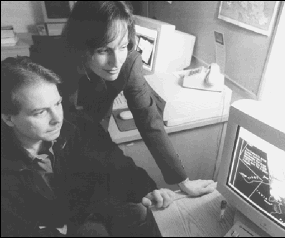
Moore, who joined Concordia in 1986, is assisted with technical support from Derek Parent, an undergraduate student in the Honours Geography program who has worked extensively with environmental groups in Central America. Parent is sorting through thousands of images and tiling them into maps that reveal the pattern of deforestation on the southeastern plateau.
He explained that the high-espionage images were obtained by the low-altitude spy satellite Corona. Conditions had to be clear, which means most of the images they are working with are from December, when the monsoons had ended and the skies were almost cloudless. As it passed over China, the satellite's optical cameras captured detailed images of the terrain.
"It was so early in the days of satellite exploration that the USGS did not yet have the capability to retrieve the images directly from the satellite. The reels spun off strips of film, which were then exposed and auto-sealed into canisters, ejected into the planet's atmosphere, then parachuted down to Earth. U.S. pilots would then snag the canisters before they fell into enemy territory," Parent said.
Moore and Parent hope to obtain more recent satellite imagery of the region from RadarSat, a Canadian company based in St-Hubert. Radar technology can penetrate through clouds and provides images in resolution comparable to 1962.
Moore has received a CUPFA Professional Development Fund grant for this project.
Photo: Professor Catherine Moore and her technical wizard, graduate student Derek Parent, track environmental damage in Asia through satellite images.
Copyright 2000 Concordia's Thursday Report. |