|
by Sigalit
Hoffman
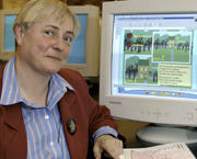
Jacqueline Anderson fell in love with maps when she was a child. Now the
Concordia geography professor is bringing her passion to elementary schoolchildren
across the province, and maybe even the world.
“I have always been interested in graphics,” she said. “As
early as the age of four and a half I can remember looking at images and
being amazed at how much information they presented.”
Anderson is working with Jean Carrière, a geography professor at
the Université de Québec à Montréal, and Janine
Le Sann, a cartography professor at the Institute of Geosciences in Brazil,
to create a prototype online atlas of Quebec for children aged eight to
17 years.
The online atlas, which will be accessed via the existing atlas Quebec
and its Regions‚ is the only one of its kind so far. Though there
are other online atlases, none are geared to children, insofar as they
incorporate good teaching tools. This one is child-centered. The site
is designed to help children identify what they know about basic mapping
concepts, learn at their own pace, and choose the topics they want to
explore.
“If you go to a paper atlas, everything is more or less fixed. With
this atlas, it’s more like a child driving a spaceship,” Anderson
said.
The existing demo Web site (http://atlasduquebec.qc.ca/scolaire/)
is colourful and easy to use and gives information of four different levels
of complexity. The site has a collection of thematic maps, links to related
sites, a glossary, and exercises to check if the student has mastered
the concepts in each level.
Though the prototype is only available in French at the moment, the professors
are hoping that English and Portuguese versions will be produced. They
expect the French version for levels one and two to be ready for schoolchildren
by September.
The professors designed the site as a response to the new educational
curriculum in Quebec, which has changed its focus from teaching children
facts to teaching children how to learn. These changes also mean that
less attention will be placed on maps in the educational cycles.
“Given the change in the curriculum, map skills won’t be a big
component in primary-level education, so it seemed that perhaps it would
be a good idea to come up with a prototype for children,” Anderson
said.
She believes that graphicacy is the “fourth ace in the pack”
of the basic skills — literacy, numeracy and articulacy — but
she has noticed that many people don’t have basic map-reading skills.
“I once had someone phone me to ask me to explain what the scale
of one to 50,000 meant,” she said. (The person was trying to calculate
moving costs).
“The individual had great difficulty in understanding that this scale
meant that two centimetres on the map represented one kilometer in reality.
It proved very difficult to explain on the phone. The final solution involved
asking the person to drive from point A to point B.”
Almost 30 years ago, Anderson’s interest in map users prompted her
to leave her job at the Ministry of Defense in London, and led to her
teaching career at Concordia.
After completing a PhD in the development of mapping skills in five- and
six-year-old children, she was co-founder, in 1995, of the International
Cartographers Association (ICA) Cartography and Children’s Commission.
In the early 1990s, “cartography and children were not a subject
in the scope of the ICA,” she said. “They were more concerned
with the education of cartographers. Given the changes in technology,
we argue that the map producers and users of the future are the children
of today.”
|